
Geographical hints: - The district was formed in November 1,1980. Wyanad district located at the north Kerala's eatern frontier near the Sahya mountains. 544 Sq.Km area is the forest. Total forest land 78,787 Hectare.
Bedecked among the High Ranges of the Western Ghats Wayanad district which lies between 700 to 2100 metres mean sea level has a predominant place in the tourist map of Kerala. A major centre of hill products the district is noted contributor of foreign exchange to the State. Apart from archaeological and anthropological uniqueness Wayanand has genuine claims for an enviable position in tourism promotion.
Wayanad has the highest concentration of tribals in Kerala. They form 1/5 of the total population of the district. It is the seat of Kurichiyas the valiant warriors of late King Pazhassi Veera Kerala Varma Raja who engaged the mighty British Army in several battles. Their descendants are still expert archers. Tribals can be seen in their natural habitat in Wayanad. Reaping the benefits of modern education and social welfare schemes many of them have developed and became part of the main stream.
Enjoying a climate similar to Udhagamandalam alias Ooty Wayanad has prospects of developing several major hill stations in the district.
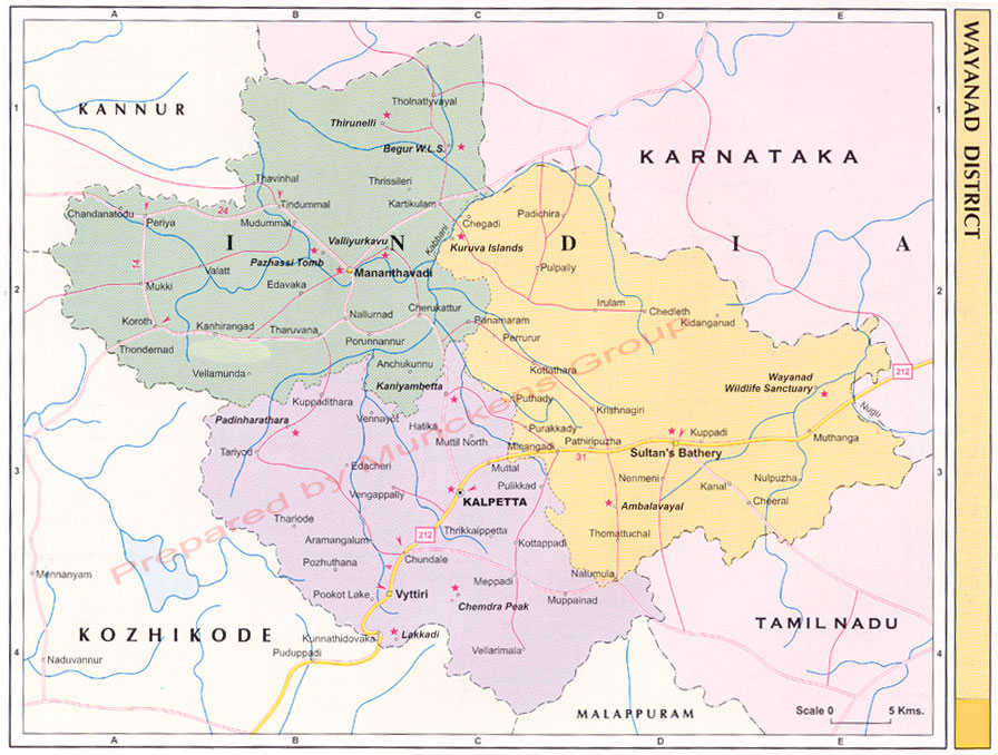
Nestled among the hills Lakkidi which is the gateway to Wayanad has the highest annual rain fall in Kerala. With mist formation in the atmosphere almost throughout the year the place has further scope for developing into a tourist centre.Lakkidi is a rain forest located in the gateway of Wayanad district of the Indian state of Kerala.
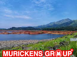
Lakkidi is one of the highest locations in Wayanad and is situated 700m above mean sea level, atop Thamarassery ghat pass. Vythiri is the nearest town, 5km from Lakkidi.Chain tree, Pookot Lake and a sightseeing point are within five km of Lakkidi. It is about 58 km northeast of Kozhikode district.Three km from Lakkidi is Pookot Lake, a natural freshwater lake spread across 15 acres. It is one of the rarest reservoirs of water in Wayanad. Surrounded by meadows and hills, it is a favourite picnic spot.Lakkidi's annual rainfall averages from 600cm to 650cm. Many species are found in this area including lion-tailed macque, rare birds, Indian Shag (Phalacrocorase fuscicollis), Little Cormorant (Phalacrocorax niger), Little Green Heron (Ardeola striatus), and Pond Heron (Ardeola grayii).Lakkidi has rich soil that supports farming of coffee, tea, oranges, spices, etc. It gets copious rainfall laterite soil. Jawahar Navodaya Vidyalaya in Wayanad district is situated here.
These are two caves in the Ambukuthy mountain. The caves contain several paintings and pictorial writings of the New Stone Age Civilization. The location is 3 Kms away from Ambalavayal and 25 Kms from the district Headquarters, Kalpetta.

Edakkal Caves also Edakal, are two natural caves at Edakkal, around 120 km south-west of Mysuru, in Wayanad district of Kerala. The caves are situated 1,200 m (3,900 ft) above sea level on Ambukutty Mala, on the Mysore Plateau, in the Western Ghats.The Edakkal caves are believed to be camping shelters of the Neolithic community (the south Indian Neolithic culture zone). The cave walls contain a collection of Neolithic rock engravings and images (which were incised over a period of time). The major part of images on the cave walls may belong to late Neolithic period (i. e., first millennium BC).With the exception of Edakkal, no concrete evidence for the existence of a true Neolithic culture in Kerala has so far been discovered.The caves were discovered by Fred Fawcett, Superintendent of Police, Malabar District in 1896[2] who immediately recognised their anthropological and historical importance. He published an article (1901) about the caves in the Indian Antiquary (Volume 30), attracting the attention of scholars.The caverns at Edakkal are not technically caves, but rather a cleft, rift or rock shelter approximately 96 ft (29 m) by 22 ft (6.7 m), a 30-foot-deep (9.1 m) fissure caused by a piece of rock splitting away from the main body. On one side of the cleft is a rock weighing several tons that covers the cleft to form the "roof" of the cave.
The wild life sanctuary at Muthaga 20 Kms from Sultan Bathery is developing into a major centre of tourist attraction. Herds of elephants, bear, deer, wild pig etc can be seen here. It is near the Begur wild life sanctuary at Karnataka.
Established in 1973, the Muthanga Wildlife Sanctuary is contiguous to the protected area network of Nagarhole and Bandipur of Karnataka on the north east and Mudumalai of Tamil Nadu on the southeast. Rich in bio-diversity, the sanctuary is an integral part of the Nilgiri Biosphere Reserve. The management lays emphasis on scientific conservation with due consideration for the general lifestyle of the tribals and others who live in and around the forest region. The Sanctuary has a large population of pachyderms and has been declared a Project Elephant site.Elephants roam freely here and tigers are sighted occasionally as well. Various species of deer, monkeys and birds also live here. The Reserve is also home to a profusion of birds, butterflies and insects. The trees and plants in the sanctuary are typical of the south Indian moist deciduous forests and semi-evergreen forests. A drive along the road to Muthanga and further, offers chances to watch these roaming animals. Elephant rides can be arranged by the Forest Department. The moist deciduous forest of Muthanga is blessed with varieties of trees and other plants. You can sight here maruthi, karimaruthi, rosewood, venteak, vengal etc. Go and get excited with the sight of wild animal like elephant, tiger, panthers, jungle cats, civet cats, monkeys, wild dogs etc. The sanctuary is also blessed with its endless population of birds like peacocks, babblers, cuckoos, owls, woodpeckers, jungle fowls etc.
Located in the valley beneath Brahmagiri hill, 66 Kms from Kalpetta, Thirunelli is referred as 'Kasi of the south' It is believed that Lord Brahma himself had installed the idol of Lord Vishnu the presiding deity of the temple. Situated among the reserve forests the location of the temple has an enchanting natural beauty.

Thirunelli Temple (also Tirunelli) is an ancient temple dedicated to Lord Maha Vishnu on the side of Brahmagiri hill in Kerala, near the border with Karnataka state. The temple is at an altitude of about 900m in north Wayanad in a valley surrounded by mountains and beautiful forests. It is 32 km away from Manathavady.No proper records of the exact dates of establishment of temple exist, though it is beyond dispute, that Thirunelli was once an important town and pilgrim center in the middle of an inaccessible jungle valley surrounded by mountains on four sides . There exists documentary proof that Thirunelli at the time of Chera king Bhaskara Ravi Varma I (962?1019 CE) was an important town and pilgrim center in South India[citation needed]. In the dense jungles surrounding temple, the ruins of two ancient villages can be found. Noted historian V. R. Parameswaran Pillai in his book Thirunelli Documents states that this temple was once an integral part of the early recorded history of Kerala.
The adjoining mountain spring called Papanasini is a major centre of pilgrimage. Papanasini means the destroyer of all sins. Thirunelli is a potential centre for eco tourism.The name Thirunelli derives from the nelli, the Tamil/Malayalam word for Indian gooseberry of the Amla tree. Veda vyasa wrote the 18 existing Puranas. The Matsya Purana, Skanda Purana, Narasimha Purana, Padma Purana, and many other Puranas and Hindu texts mention the beautiful Vishnu temple as being built by Lord Brahma, located in the picturesque Sahya valley, deep in the middle of forest of unmatchable beauty, and in these texts, it is referred to as "Sahyamalaka Kshetra."According to tradition, Lord Brahma was traveling round the Universe on his hamsa, when he became attracted by the beauty of the area now known as Brahmagiri Hill. Descending on that spot, Brahma noticed an idol, set in an Amla tree. Brahma recognized the idol as Lord Vishnu Himself and the place as Vaikuntha (Vishnuloka) itself. With the help of the Devas, Brahma installed the idol and called it Sahyamalak Kshetra. At Brahma?s request Vishnu promised that the waters of the area would wash away all sins. (Thus, the spring and river near the temple is called Papanasini: "washes away all sins"). Even today the head priest of the temple leaves a portion of the worship materials in the belief that Lord Brahma Himself will come and perform pooja rites deep in the holy hours of morning.
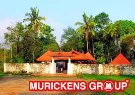
The Glass Temple of Kottamunda, located 20 Kms from Kalpetta, on the slope of Vellarimala, is a famous Jain family Temple in Wayanad. It is dedicated to Paraswanatha Swamy the third Thirthankara of the Jain faith. Icons of Parswanatha Swamy and this temple have thousand reflections in beautiful patterns on the mirrors placed on the inner side of the temple walls.

Situated about 20 km from Kalpetta, there lies another famous Jain temple, on the slopes of Vellarimala. It is dedicated to the third Thirthankara of the Jains, Parswanatha Swami. The exquisite beauty of the temple owes a lot to its construction. There are icons of Parswanatha Swami and Padmavathi Devi in the sanctum of the temple. Mirrors are placed in the inner walls of the temple and you can see numerous beautiful patterns of the reflections of these idols in these mirrors.An important pilgrimage for Jains, Koottamunu Glass Temple was created to honor the famous Jain saint Parshawanatha Swami. Situated 22 km from Kalpetta on the hill side Vellarimala, devotees come here to pay their respect and meditate. The interior of the temple is quite tantalizing decorated with mirrors reflecting the image of the idols inside the main temple. A perfect getaway from all the usual sightseeing in Wayanad, this temple is located in the hills of Vellarimala. The Glass temple truly showcase its name since it is filled with thousands of Glass mirrors, and is perfect for an awe-inspiring experience. It is a photographer delight since the temple is beautiful and unique in its own sense, nestled in the green hills it is a delight for nature lover as well. There is no entry fee to enter into the premises, to give you a delightful experience. Located 20 km away from the Kalpetta, you can reach here via local taxi or cabs. The best time to visit here is from October to May.
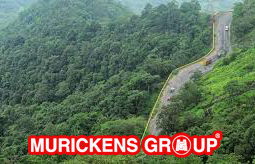
Located between Lakkidi and Kalpetta Pookkode is a very attractive freshwater lake around 2000 metres above mean sea level. Contoured by lush green forests the lake has good prospects for boating facilities. It is one of the major centres of eco-tourism in Wayanad

The beautiful freshwater lake in Wayanad, Pookode Lake lays 15 kilometre away from Kalpetta. Nestled between evergreen forest and Western Ghats, the lake is spread over 13 acre and is 40 m deep. This is one of the most preferred tourist destinations in Wayanad. While reaching at this gorgeous lake, you will be experiencing a calm and peaceful environment around. The lake is surrounded by forest and you will see green and green all around, making this place an ideal location for photographers and nature lovers. One of the main tributary of Kabini River, the Panamaram rivulet originates from here. The perennial freshwater lake has the shape of an Indian map. You can sight blue lotus and numerous fresh water fishes. Blue water lilies also can be seen scattered here and there in the water. The sight of wild animals and birds in the surrounding forest of the lake is another attraction of this destination. Plenty of monkeys are also seen here. Pethia Pookodensis is a species of cyprind fish, which is said to be found here only.
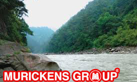
Established in the year 1905 by a French Missionary Fr. Jeffrine, this is one of the unique churches in Kerala. The interesting aspect is that it follows some rituals that are similar to those prevalent in Hindu temples. The annual two week "Perunnal" festival celebrated in the month of February draws large visitors from different parts of the state. The temple is 19 kms. away from Kalpetta, 38 Kms. away from Sulthan Bathery.
Pallikkunnu Church, also known as Our Lady of Lourdes Church,is a pilgrim centre of North Kerala.This is a Latin Catholic church The festival is on February 2 to 18. Main days are 10th and 11th.Pallikkunnu Church was built by a French priest Fr. Jefreno in 1908.Approximate distance to the church from Kalpetta is 14 kilometersPopularly known as ' Our Lady of Lourdes ' Church, Pallikkunnu Church was dedicated to Lourdes Matha. It was established by a French priest Fr. Jefreno in 1908 in European style. The church has a mesmerizing green surroundings and the calmness and serenity of the surroundings coupled with its peculiar architecture adds to its charm. An interesting aspect of this church is that it has several rituals and practices similar to those prevalent in Hindu temples. The annual festival of the church is celebrated for 3 days starting from 10th February every year and it draws large number of devotees from other parts of Kerala, as well as outside. Timings: 7 AM - 7 PM
Chembra peak is 14 kms southwest of Kalpetta and is good for trekking and bird watching. This is the highest hill of the district that measures District Tourism Promotion Council provides guides, sleeping bags, canvases, huts and trekking implements on hire. The scenic beauty of Wayanad, which is visible from the top of Chambra, is very exhilarating.

Chembra Peak (Chembra Mala) is one of the highest peak in the Western Ghats and the highest peak in Wayanad hills, at 2,100 m (6,890 ft) above sea level.Chembra is located near the town of Meppadi and is 8 km (5 mi) south of Kalpetta. It is part of the Wayanad hill ranges in Western Ghats, adjoining the Nilgiri Hills and Vellarimala in Kozhikode district in Kerala. It is the highest and the largest peak in Western Ghats of India in between Nilgiris and Himalayas exceeding 2,000m . Visits to this peak organized by 'the Chempra Peak VSS' under the control of South Wayanad Forest Development Agency, guides are provided for trekking. Chembra Peak is accessible by foot from Meppady. District Tourism Promotion Council provides guides and trekking equipment on hire charges to tourists. Banasura Sagar Dam and Banasura Hill is also nearby.
Considered to be the largest earth dam in India, the Banasura project precincts are an ideal starting point for treks to the Banasura Peak. An interesting feature is a set of islands that were formed when the reservoir submerged the surrounding areas.
Banasura Sagar Dam, which impounds the Karamanathodu tributary of the Kabini River, is part of the Indian Banasurasagar Project consisting of a dam and a canal project started in 1979.The goal of the project is to support the Kakkayam Hydro electric power project and satisfy the demand for irrigation and drinking water in a region known to have water shortages in seasonal dry periods. In the dam's reservoir there is a set of islands that were formed when the reservoir submerged the surrounding areas.The islands with the Banasura hills are in the background view.It is the largest earth dam in India and the second largest of its kind in Asia. The dam is made up of massive stacks of stones and boulders.The dam has become a popular tourist destination. Many people visit the place to go trekking at the Banasura Hill & speed boating at Banasura Sagar Dam. The Banasura Hill Resort, located about 20 km from the dam was rated as Asia's largest Earthen Resort by BBC. Speed & pedal boats are available & are major hits with tourists. Speed boat ride, in particular, is an exhilarating experience & not to be missed.
Tribal communities of Wayanad. A 15 day festival is held every year during March/April. The temple is 24 Kms. away from Kalpetta, 31 Kms. away from Sulthan Bathery.
Valliyoorkkavu is an ancient Bhagavathy temple located near Mananthavady in Wayanad district.[1] The temple is for Goddess Durga as its presiding deity in three forms namely: Vana Durga, Bhadrakali, and Jala Durga. Valliyoorkkavu Temple The idol of the temple is believed to be self-manifested and the annual festival falls in the month of March and will lasts for 14 days. The festival is a major event and thousands of people from all over the place takes part in this biggest event.[2] The temple has many numerous rituals held during the festival include the oppana varavu, a procession from Cheramkode Bhagavathy temple at Kallody near Mananthavady and Adiyaras, a procession with tender coconut for abhishekam (ablution) marks the arattu of Valliyooramma. The festival concluded when the oppana varavu returns to Cheramkode Bhagavathy temple after the rudhirakkolam, a symbolic fight between Goddess and the demon king, Darika, in which the Bhagavathy wins. The festival is very important for the tribal people of Wayanad. The traditional ritual of Kalamezhuthu is performed during the nights of festival. On the final day, the array of folk art forms are presented. The dances are performed by the local tribes with native percussion instruments, is a major attraction. Also the scenic beauty of the place with hillocks and Kabani River is worth seeing.
This is a beauthiful waterfall, which is falling from about 30 mtrs 0f height. Relatively smaller than Sentinel Rock Falls, and rather less frequented Kanthanpara and its surroundings offer a very pleasant site

Kanthanpara is a quaint little waterfall in Wayanad, famous for its secluded and serene vibe. The cool, sparking waters at this lesser known destination is sure to soothe all who wish to rejuvenate in a silent environment. Surrounded by beautiful greenery on all sides, it is worth spending a day a picnicking in the calming embrace of nature.Close to the iconic attractions of Kerala - Meeenmutti and Soochippara falls stand their small version - Kanthanpara waterfall that drops down from an altitude of 30 meters. It is small in size but the best part about is that as compare to other places it is easily accessible. Also, one can hardly find any tourists rush. This scenic and quaint waterfall is a must visit place for every tourist on a trip to Wayanad. Locations of the surroundings and its picturesque waterfall make it the best place for camping as well.The waterfall is 18 kilometers to the southeast of Kalpetta, and 8 kilometers to the east of Meppadi on Vaduvanchal road. If planning to visit here by personal transport then be a little cautious about the roads. The best part about this place is one doesn't need to walk a lot to reach here.
Legend has it that an Adivasi youth named Karinthandan was instrumental in guiding the British Engineer through the difficult mountain terrain into Wayanad. Eager to take credit for the discovery, the engineer conveniently killed his guide, whose soul, according to the legend, constantly haunted subsequent.
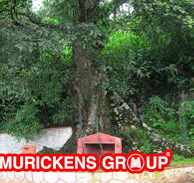
Chain Tree is a popular Ficus, which has many myths associated with it. According to one of the legends, the road up was built by a foreign engineer but the route was given to him by a local tribal youth who was shot to death by the engineer. His spirit is said to have stuck to the tree causing many accidents on the hair pin curve. Another story says that when the British first came to Wayanad, the Adivasi Mahouts took them to the top the mountains. As the Portuguese were close behind them, they did not want the Mahouts to go back and get the Portuguese. Hence they killed the Mahout whose spirit lived in the area causing accidents. A local priest later chained the spirit to the tree with a chain over it.
MURICKENS GROUP
HO : KOTTAYAM-KADUTHURUTHY
BR : KOTTAYAM- CEMENT JUNCTION
ERNAKULAM-PALARIVATTAM
Real estate cunsulting officials at U.S.A. (Texas & Newyork) & Bombay
Email : mg@murickens.com, murickans@gmail.com